Products
Professional Services
Demos and Downloads
Help and Support
Products
Professional Services
Demos and Downloads
Help and Support
The Data Repository window exposes a collection of folders on your computer or network that contain map data you frequently access. It provides a quick way to load layer data onto your map without searching for it on the file system every time. Using the Data Repository, you can access data stored on a wide variety of different locations or computers, or even Base Maps like Bing or OpenStreetMap, all from one place.
The Data Repository is designed to be a single point of access for all of the map data (both raster and vector) that you use on a regular basis. Although you can easily load new layers into the GIS Editor by browsing for them like you would any other file, this quickly becomes tedious when you have data stored in many different locations on your hard drive or network, or when you can't remember the physical path to your data. With the Data Repository, you need only make a one-time connection to that physical path. From that point on, the data can be accessed directly from your Data Repository window.
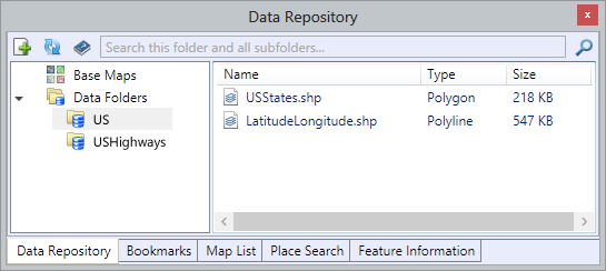
Here's an example. Let's say you have a set of data for the United States interstate highway system stored in D:\Data\USHighways. You also have some basic outlines of the U.S. states in C:\My Documents\GIS\US. You could add both locations to your Data Repository, after which the data would be accessible from a single window as shown in the following screenshot.
In the above scenario, you might also choose instead to make a connection to the parent folders of the paths specified – in this case, D:\Data and C:\My Documents\GIS. This would automatically include all of their subfolders in your Data Repository, so if you had other data stored under those paths, it would automatically be found and made available.
In addition to physical, file-based data, the Data Repository also warehouses Cloud Based Map Data that you can add to your map. Base Maps are tile-based maps like Bing Maps or OpenStreetMap that serve as a backdrop to your map. Cloud layers and Third Party Layers are sets of data that are rendered in the cloud and then delivered over the Internet to your GIS Editor application.
Making a folder connection effectively makes the contents of that folder available in your Data Repository. To make a new folder connection, click the ![]() in the top left corner of the Data Repository window. In the “Browse for Folder…” dialog that appears, locate the folder you want to connect to the Data Repository and then click the “OK” button.
in the top left corner of the Data Repository window. In the “Browse for Folder…” dialog that appears, locate the folder you want to connect to the Data Repository and then click the “OK” button.
At this point, the folder you just selected will be added as a child of the “Data Folders” node in the Data Repository's folder tree.
You can also make connections to folders on networked drives, although please be aware that performance of the Data Repository may be compromised if the folder in question contains a large amount of data (read: hundreds of gigabytes).
Renaming
Right-click on any folder connection and choose “Rename” to rename it. Note: When you do, the name of the corresponding physical folder on your file system will also be changed. If you don't have permissions to change the name of the physical folder, you will not be able to rename it in the Data Repository.
Removing
Right-click on any folder connection and choose “Remove from Repository” to remove the folder connection from your Data Repository. This will not delete the folder or its contents from your computer; it will only disconnect it from your Data Repository.
Showing in Windows Explorer
Right-click on any folder connection and choose “Show in Windows Explorer” to open an Explorer window to the location where the selected folder physically resides. The folder will be automatically highlighted so you can easily browse into it if you desire.
You can load data from the Data Repository by simply double-clicking it, or by clicking and dragging the highlighted data item directly onto the map window.
Most data types can be added instantly. In some cases, the GIS Editor may ask you to provide additional details about the data in question before it can be loaded. For example, Shapefiles for which projection information has not been defined will require you to specify projection details. Some types of raster image data may also ask you to specify coordinate information before the GIS Editor can determine how and where to draw them on the map.
Files containing comma-separated values (CSV) can also be stored in your Data Repository. When you attempt to add a CSV file to your map, the Configure Delimited File window will appear, enabling you to set up the CSV file for proper display. Your CSV file must contain either a separate column for latitude and longitude coordinates of each record, or Well-Known Text (WKT) that defines the shape and location of each record.
![]()
8501 Wade Blvd Ste 550
Frisco, TX 75034
United States
sales@thinkgeo.com
1-785-727-4133
Online Store
- Desktop
WPF
WinForms
- Web
WebAPI HTML5/JavaScript
ASP.NET MVC
WebForms with AJAX
- Mobile
iOS
Android™
World Street
World Imagery
Routing
Geocoding
Reverse Geocoding
Elevation
Quick Start Guides
Documentation
Blogs
Discussion Forums
Customer Portal
About Us
News & Announcemets
Privacy Policy
Copyright 2003-2017 ThinkGeo LLC.
All rights reserved.