Products
Professional Services
Demos and Downloads
Help and Support
Products
Professional Services
Demos and Downloads
Help and Support
This is an old revision of the document!
Navigating the map in the GIS Editor consists of panning and zooming to locate the area and magnification that interests you. As part of navigating your map, you may also want to identify one or more of the features you see on it. All of this can be done using a variety of controls available to you on the GIS Editor's Ribbon Bar, or by using some of the GIS Editor's global shortcut keys from anywhere in the application.
The Pan/Zoom controls can be found in the upper left corner of the map area. At the top is a circular control pad that switches the GIS Editor into one of three map interaction modes: Pan Mode, Track Zoom Mode and Identify Mode. Beneath the control pad is the zoom bar, which you can use to zoom the map in and out.
The circular control pad allows you to choose between one of the three most common map interaction modes, as described below. Each mode is represented by a different mouse cursor appearance when the cursor is over the map itself.
{| class=“wikitable” cellpadding=“3” ! Control Pad ! Interaction Mode ! Mouse Cursor ! What It Does
| style=“text-align:center;” |
| style=“text-align:center;” |
| style=“text-align:center;” |
| style=“text-align:center;” |
| style=“text-align:center;” |
| style=“text-align:center;” |
The zoom bar can be used to zoom the map in or out. You can click the “+” button at the top of the bar to zoom in, or click the “-” button at the bottom of the bar to zoom out. Additionally, you can zoom by dragging the slider along the length of the bar. Drag the slider up to zoom in, or down to zoom out. If you hover over the slider, you will see a tooltip indicating the current zoom level of the map.
You can also determine the map's current zoom level by looking at the right side of the status bar at the bottom right corner of the GIS Editor's main window.
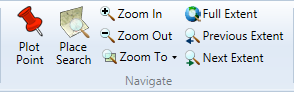
The Home tab of the GIS Editor's ribbon bar also contains several buttons that let you control the zoom of the map.
{| class=“wikitable” cellpadding=“3” ! Button ! What It Does
| style=“padding-left:10px; padding-right:10px; white-space:nowrap;” |
| style=“padding-left:10px; padding-right:10px; white-space:nowrap;” |
| style=“padding-left:10px; padding-right:10px; white-space:nowrap;” |
| style=“padding-left:10px; padding-right:10px; white-space:nowrap;” |
| style=“padding-left:10px; padding-right:10px; white-space:nowrap;” |
| style=“padding-left:10px; padding-right:10px; white-space:nowrap;” |
You can use your keyboard and mouse to pan or zoom the map regardless of what interaction mode the GIS Editor is in.
Panning: Use the keyboard's arrow keys to pan north, south, east or west by a fixed amount, or hold down the space bar and click and drag with your mouse.
Zooming: Use the mouse wheel to zoom in or out. (Scroll up to zoom in, down to zoom out.)
![]()
8501 Wade Blvd Ste 550
Frisco, TX 75034
United States
sales@thinkgeo.com
1-785-727-4133
Online Store
- Desktop
WPF
WinForms
- Web
WebAPI HTML5/JavaScript
ASP.NET MVC
WebForms with AJAX
- Mobile
iOS
Android™
World Street
World Imagery
Routing
Geocoding
Reverse Geocoding
Elevation
Quick Start Guides
Documentation
Blogs
Discussion Forums
Customer Portal
About Us
News & Announcemets
Privacy Policy
Copyright 2003-2017 ThinkGeo LLC.
All rights reserved.